|
Country
|
Area
|
Subject
|
Year taken
|
|
|
Base Jumping |
|
| |
|
Hot-air
balloon |
|
| |
|
Imax Skydiving |
|
| |
|
Parachuting |
|
| |
|
Parafan |
|
| |
|
Paragliding |
|
| |
|
Skydiving from Hot-air Balloon |
|
| |
|
Skydiving
from plane |
|
| Australia |
Great
Barrier Reef |
Landscape |
|
| Australia |
Heron Island |
Landscape |
|
| Australia |
Daintree, Queensland |
Mangrove and Rainforest |
|
| Australia |
Daintree, Queensland |
Tropical
Rainforest |
|
| Australia |
Queensland |
Tropical Rainforest |
|
| Australia |
Victoria |
Eucalyptus Forest |
|
| Borneo |
|
Tropical Rainforest |
1981 |
| Brasil |
Amazon |
Amazon-Brasil Floodplain |
|
| Brasil |
Amazon |
Rain Forest |
|
| Brasil |
Rio Jurua |
Rain Forest |
|
| Brazil |
|
Amazon-Brazil Floodplain: Aerial |
|
| Brazil |
Amazon |
River with Oxbow |
|
| Brunai |
Temburoy |
Tropical Rainforest |
|
| Brunai |
Temburoy |
Tropical Rainforest: Aerial |
|
| Canada |
Bay of Fundy |
Mudflats |
|
| Canada |
Bay of Fundy |
Tidal Surge |
|
| Canada |
Bay of Fundy |
Tidal Whirlpool |
|
| Costa Rica |
Monteverde |
Cloud
Forest |
|
| Cota Rica |
|
Tropical
Rainforest |
|
| Djibouti/Ehiopia Border |
|
Gulf of Tadjoura |
|
| Djibouti/Ehiopia Border |
|
Lac Abbe (with Mineral Pillars) |
|
| Djibouti/Ehiopia Border |
|
Landscape |
|
| Djibouti/Ehiopia Border |
|
Lava Field |
|
| Djibouti/Ehiopia Border |
|
Volcanic Landscape |
|
| Djibouti/Ehiopia Border |
|
Volcano Adoukouba |
|
| Djibouti/Ehiopia Border |
Djibouti/Ehiopia Border |
Volcanic Island |
|
| Djibouti/Ehiopia Border |
Near Adoukouba |
New Fault Line |
|
| Djibouti/Ehiopia Border |
Red Sea Coast |
Ras Syan |
|
| Ecuador |
Cononaco Area |
Waorani
Indian :Settlements from Air) |
1983 |
| Ecuador |
Cononaco Area |
Waorani Indian: oil Company Settlement |
1993 |
| Ecuador |
Cononaco Area |
Waorani Indian: Settlement at Cononaco Airstrip) |
1993 |
| Ecuador |
Cononaco Area |
Waorani
Indian; Home of Tagaeri |
1993 |
| Ecuador |
Cononaco Area |
Waorani
Indian; Maxus oil Company |
1993 |
| Ecuador |
Rio Cononaco |
Tropical
Rainforest with Ox-Bow lake: Aerial |
|
| Ecuador |
Rio Cononaco |
Tropical
Rainforest: Aerial |
|
| ENGLAND |
|
Over 600 locations, and to cover
the whole England and Wales by the end of 2003 |
|
| France |
Cap Blanc Nez |
Cliffs |
|
| Indonesia |
Halmahera Island |
Forest |
|
| Israel |
|
Negev Desert; Landscape from air |
|
| Israel |
Near Negev Desert |
Landscape with Migrating Storks from air |
|
| Israel |
Galilee |
Landscape |
1974 |
| Kenya |
|
Aerial: North Frontier |
|
| Kenya |
|
Mts. Kenya |
|
| Kenya |
Aberdare Highlands |
Aberdare Mts. Kenya |
|
| Kenya |
Aberdare Mts. Kenya |
Waterfall |
|
| Kenya |
African Rift Valley |
Lava Flow |
|
| Kenya |
African Rift Valley |
Mount
Longonot |
|
| Kenya |
African Rift valley |
Mount Suswa |
|
| Kenya |
Hell's Gate |
Basalt Cliffs/ Lava |
|
| Kenya |
Mount Kenya |
Landscape |
1977 |
| Kenya |
Over Masai Mara |
Hot Air Balloon incl. with Wildebeest |
|
| Kenya |
Northern Frontier District |
View from the Air |
1977 |
| Kenya |
Rift Valley |
Landscape |
|
| Korea |
|
Mt. Changbaisan |
|
| Namibia |
Etosha Nat. Park |
Boundary Fence |
|
| Namibia |
Etosha Nat. Park |
Bushfire |
|
| Namibia |
Etosha Nat. Park |
Koakoland |
|
| Namibia |
Etosha Nat. Park |
Salt Pan |
|
| Namibia |
Etosha Nat. Park |
View of Etosha Nat Park from Air |
|
| Namibia |
Etosha Nat. Park |
Water Hole |
|
| Namibia |
Etosha Nat. Park |
Windmill |
|
| Namibia |
Near Opuwo |
Himba Settlements from Air |
|
| Papua New Guinea |
|
Rain Forest |
|
| Rwanda |
|
Virunga Volcanoes |
1996 |
| Rwanda |
Near Virunga Volcanoes |
Misty Forest Dawn |
1991 |
| Rwanda |
Nyungwe Forest |
Misty Forest |
1990 |
| Rwanda |
Virunga Volcanoes |
Mt. Karisimbi |
|
| Rwanda |
Virunga Volcanoes |
Mt. Mikeno |
|
| Rwanda |
Virunga Volcanoes |
Mt. Sabyinyo |
|
| Rwanda |
Virunga Volcanoes |
Visoke Crater Lake |
|
| South Africa |
Drakensberg Mts |
Landscape: Drakensberg Mts |
|
| Spain |
Pyranees |
Landscape |
|
| Surinam |
|
Tropical Rainforest |
|
| Switzerland |
|
Aerial: Alps from air |
|
| Tanzania |
African Rift Valley |
Aerial: Mount Lengai |
1988 |
| Tanzania |
African Rift Valley |
Aerial: Mount Lengai |
1999 |
| Tanzania |
African Rift Valley |
Lake Natron |
|
| Tanzania |
African Rift Valley |
Lake Natron (CU of Coloured Water) |
|
| Tanzania |
African Rift Valley |
Mount Lengai |
1988 |
| Tanzania |
African Rift Valley |
Mount Lengai |
1999 |
| Tanzania |
African Rift Valley |
Mount Lengai Crater |
|
| Tanzania |
Gomb |
Gomb Stream Nature Reserve, Landscape |
1993 |
| Tanzania |
Ngorongoro |
Masai Enclosure: from air |
1998 |
| Tanzania |
Ngorongoro |
Masai Village |
1998 |
| Tanzania |
Ngorongoro Crater |
Aerial; Ngorongoro Crater |
1998 |
| Tanzania |
Serengeti |
Landscape |
|
| Tanzania |
Serengeti |
Landscape after rain |
|
| USA |
|
Giant Sequoias |
|
| USA |
Idaho |
Lava Flow |
|
| USA |
Kings Canyon Nat. Park |
Glacial Valley |
|
| USA |
Kings Canyon Nat. Park |
Landscape |
|
| USA |
Montana |
Wheatfields |
|
| USA |
near Bakersfield, CA |
Oilfields |
|
| USA |
North Dakota |
Floods at Grand Forks |
1997 |
| USA |
Sequoia Nat. Park |
Forest |
|
| USA |
Sequoia Nat. Park |
Forest Fire |
|
| USA |
Sequoia Nat. Park |
Landscape |
|
| USA |
Yellowestone Nat. Park |
Fire
Damage |
|
| USA |
Yellowestone Nat. Park |
Grand
Prismatic Hotspring (incl. aerial views) |
|
| USA |
Yellowestone Nat. Park |
Landscape |
|
| Venezuela |
|
Angostura Bridge over Orinoco |
|
| Venezuela |
|
Ants; Leaf cutting |
|
| Venezuela |
|
Rain Forest |
|
| Venezuela |
|
Rain forest with Ox-Bows |
1974 |
| Venezuela |
Estado Bolivar |
Rainforest |
|
| Venezuela |
Tepuis |
Aerial: Auyantepui |
1976 |
| Venezuela |
Tepuis |
Aerial:
Auyantepui |
2000 |
| Venezuela |
Tepuis |
Aerial: Forest and Tepuis |
|
| Venezuela |
Tepuis |
Aerial: Gran Sabana |
1976 |
| Venezuela |
Tepuis |
Aerial:
Gran Sabana |
2000 |
| Venezuela |
Tepuis |
Autana Expedition |
1985 |
| Venezuela |
Tepuis |
Aerial: Autana |
1985 |
| Venezuela |
Tepuis |
Aerial: Kukenaam |
2000 |
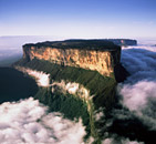
| Venezuela |
Tepuis |
Aerial:
Roraima |
2000 |
| Venezuela |
Tepuis |
Auyantepui Expedition |
1976 |
| Venezuela |
Tepuis |
Kukenaam Expedition |
1981 |
| Venezuela |
Tepuis |
Roraima Expedition |
1971 |
| Venezuela |
Tepuis |
Roraima Expedition |
1974 |
| Venezuela |
Tepuis |
Roraima Expedition |
1974 |
| Venezuela |
Tepuis |
NEWEST COLLECTION:
We have a large collection of aerial pictures from the area (mainly
of Angel Falls, Auyantepui, Roraima, Kukenaam and Surrounded areas) |
2001 |
| Venezuela |
Tepuis |
Sarisarinama
Sink Hole |
2000 |
| Wales |
|
Aerial: Wind Turbines |
|
| Wales |
|
Aerial:
Snowdonia |
|
| Wales |
|
Aerial
: Brecon Beacons (under mist and clouds in Winter) |
|
| Wales |
|
Aerial
: Brecon Beacons ( fields and patterns) |
|